Connect with us
https://tickernews.co/wp-content/uploads/2023/10/AmEx-Thought-Leaders.jpg

Ticker Views

The Cold War maps that can help us rethink today’s Arctic conflict

Published

on

The Cold War maps that can help us rethink today’s Arctic conflict

A US view of the cold war world, 1950, showing the fearsome power of the USSR.
Cornell University – PJ Mode Collection of Persuasive Cartography.

James Cheshire, UCL

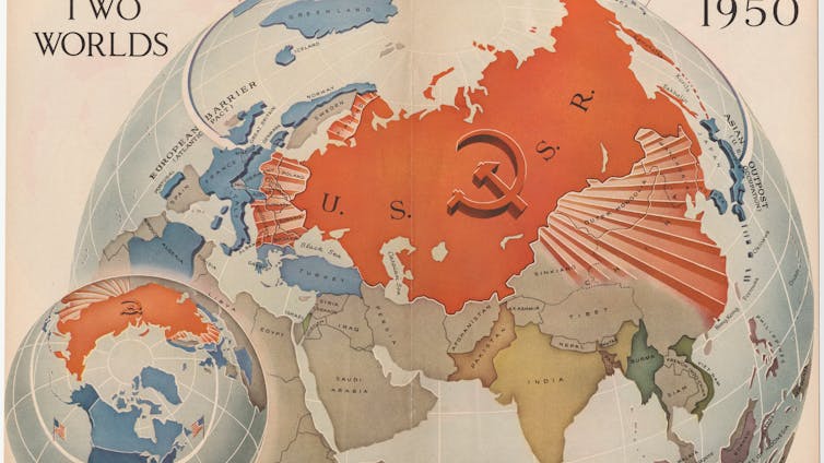
The late 1940s and early 1950s were a golden age for polar mapmaking in the US. Major magazines such as Time, Life and Fortune commissioned a generation of famous cartographers – who had come of age in the second world war – to explain the new geopolitics to a mass audience that was highly engaged after the catastrophic global conflict they had just lived through.

Their maps were large, dramatic and designed to be spread across kitchen tables and classroom desks. And they also offered a very different perspective to the mainstream maps we have become accustomed to today.

I’ve spent the past four years unearthing maps from the late 1940s and early 1950s to research a book about a largely forgotten map library at my university, and I am always struck by how consequential they feel to the global arguments of their era. Not least because they invited debate from their readers who were asked to become global strategists by discussing the next moves in the game of geopolitics.

These maps didn’t just illustrate the world – they implored people to think about it differently. As the world enters a new period of international relations and global tensions, it’s worth considering the different perspectives maps can offer us.

With each new US foreign policy intervention – such as the US president’s current preoccupation with taking over Greenland – I have often wondered if these maps of global adversaries could have percolated into a young Trump’s mind. The world must have seemed a menacing place and it is shown on these maps as a series of threats and opportunities to be gamed, with the “Arctic arena” as a major venue.

A map showing the political alignments as they were in 1941
The World Divided is an iconic map showing the geoopolitical situation at the height of the second world war. It was created by Richard Edes Harrison and published by Fortune Magazine in August 1941.
Cornell University – PJ Mode Collection of Persuasive Cartography.

The consensus encouraged by the maps was that of alliances, most notably Nato, and US opinion tended to endorse what Henry Luce, the influential owner of Time and Life magazines, called the “American century” in which the US would abandon isolationism and take on a global role.

a map using the North Polar Azimuthal Equidisant Projection
Published in 1950, this map introduces the Azimuthal Equidistant Projection to Time Magazine’s readers.
Time Magazine

Whatever one thinks of that worldview, it was frequently framed in terms of collective responsibility rather than individual dominance. Luce argued that the “work” of shaping the future “cannot come out of the vision of any one man”.

As we can now see with Greenland, Trump has taken the geography of threats and opportunity shown on these influential maps but reached a very different conclusion: an “America first”, resulting from the vision of the US president himself.

Dawning of the ‘air age’

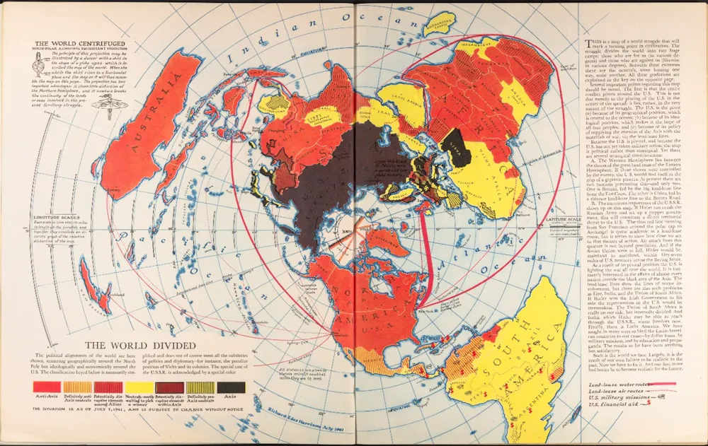
The skilful of the cartographers of the era played with a range of map projections that offered different perspectives of geopolitical arenas. The master of this was Richard Edes Harrison who is described by the historian Susan Schultern as “the person most responsible for sensitizing the public to geography in the 1940s. [The public] tore his maps out of magazines and snatched them off shelves and, in the process, endowed Harrison himself with the status of a minor celebrity.”

Edes Harrison adopted many projections in his work – but for maps of the Arctic, he alighted on the azimuthal equidistant projection. While this creates maps that distort the shapes of countries, it enables the correct distances to be shown from the centre point of the map.

The projection became widely used in the 1940s and 1950s (and was indeed adopted for the UN flag in 1946) because it proved effective at demonstrating the wonder of the burgeoning “air age” as commercial flights followed great circle routes over the Arctic.

World map centered on London 1945
The Air Age Map of The World, 1945 (centered on London).
The Library of Lost Maps

This contrasted with the roundabout routes that needed to be followed by ships and it also mapped the countries that bordered and occupied the Arctic with a much greater sense of proximity and threat.

Missiles and bombers were just as able to travel over the top of Earth as were holidaymakers – and this created a juxtaposition exploited by cartographers. Rand McNally, a renowned map publisher, for example, published a collection of maps entitled Air Age Map of the Global Crisis in 1949.

These set out “the growing line-up of countries and peoples behind the two rival ways of life competing for power in the 20th Century” – that is capitalism as embodied by the US and Soviet and Chinese communism.

Those who bought it were told: “Keep this map folder! It may have great historic significance a generation from now.”

Magazine insert from 1950s with a series of geopolitical maps.
This 1950s map published by Rand McNally was produced as part of a marketing campaign for Airwick air freshener, but also sought to inform the US public about the spread of communism.
Rand McNally

New world order

Donald Trump’s return to office has revived talk of a world moving beyond the assumptions of the postwar order — weakening alliances, acting unilaterally, treating territory as leverage. At the same time, maps remain one of the most trusted forms of evidence in public life.

A Mercator-shaped worldview, widely used by digital maps can distort reality – for example, making Greenland much larger than it is.

Cartographers have long known the strengths and limitations of Mercator, but Trump’s approach to foreign policy is a further reminder of the perspective we lose when we depend on the standardised views of Earth that digital maps encourage (some have also speculated that Mercator’s exaggeration of Greenland’s area heightens its real estate appeal to Trump).

Maps are powerful things and in times of crisis, or rapid change, we turn to them to help explain events and locate ourselves within them. But they can be just as much about arguments as they are facts – and Trump knows this.

The maps of the 1940s and 1950s were about a fresh (American) perspective to create a new world order. They instilled Trump’s generation with a sense of the geopolitical rivalries that tend to get washed out of generic digital maps that are most widely consumed today.

Nearly 80 years on, this order may be creaking – but the maps are still there to remind us of what’s at stake.The Conversation

James Cheshire, Professor of Geographic Information and Cartography, UCL

This article is republished from The Conversation under a Creative Commons license. Read the original article.

Ticker Views

DOJ reveals high-profile names linked to Epstein case

DOJ reveals prominent figures linked to Epstein case, including Trump, sparking renewed interest and calls for transparency.

Published

on

DOJ reveals prominent figures linked to Epstein case, including Trump, sparking renewed interest and calls for transparency.


The Department of Justice has released a list of prominent individuals connected to the Jeffrey Epstein case, including current President Donald Trump. This disclosure comes as part of its formal response to Congress and the Epstein Files Transparency Act. The move has reignited public interest in one of the most controversial investigations in recent history.

Oz Sultan from Sultan Interactive Group provides insight into what this list could mean for ongoing investigations, and why transparency is a critical factor in holding powerful figures accountable.

Subscribe to never miss an episode of Ticker – https://www.youtube.com/@weareticker


Download the Ticker app

Continue Reading

Ticker Views

Trump scraps key climate law, U.S. emissions regulation at risk

Published

on

Trump has scrapped the long-standing legal basis for tackling climate emissions

Robyn Eckersley, The University of Melbourne

Regulating climate emissions just became more difficult. US President Donald Trump announced on Thursday the Environmental Protection Agency (EPA) has repealed its own 2009 legal finding that greenhouse gas emissions endanger human health.

Vindicated by a Supreme Court ruling in 2007, and based on scientific evidence, this so-called endangerment finding by the EPA provided the legal warrant for the regulation of greenhouse gases by the federal government. It underpinned the Obama administration’s Clean Power Plan, which regulated emissions from power plants. In his first term, Trump had tried to weaken it but a new version was introduced by the Biden administration.

Without the endangerment finding, and in the absence of new laws passed by both Houses of Congress, the federal government lacks the legal mandate for direct regulation of greenhouse emissions. The science hasn’t changed, but the obligation to act on it has been scrubbed out.

If you imagine the United States as a collection of big greenhouse gas pots with lids, the Trump administration has been lifting the lids off one by one, releasing more emissions by stepping up fossil fuel extraction, production and consumption. This legal finding held down the biggest lid on climate emissions — and Trump has pulled it right off. This will have a structural effect globally.

What is the endangerment finding, and how was it developed?

In 1970, when the US environment movement was at its most influential, Congress passed an important piece of legislation called the Clean Air Act. It empowered the new Environmental Protection Agency (EPA) to declare something a pollutant if it endangered public health. Initially, it was used to regulate pollutants such as smog or coal ash, the byproducts of industry.

During the George W. Bush presidency, the EPA made a ruling that greenhouse gases were also a pollutant within the meaning of the Clean Air Act. This ruling was challenged in 2007 by fossil fuel interests in the case of Massachusetts v EPA, but the court ruled (five judges to four) that carbon dioxide and other greenhouse gases were “air pollutants” that endangered human health and welfare. It directed the EPA to assess their impact on human welfare — allowing the agency to regulate them.

However, the Bush administration did not push the EPA to implement the ruling.

How was the endangerment finding used for climate action?

President Barack Obama promised to act on climate during his election campaign but faced a hostile Senate when he came to power. His efforts to enact an emission trading bill failed.

However, the endangerment finding allowed him to use his executive power to direct the EPA to regulate emissions. In his first term, the EPA issued new vehicle emissions regulations for cars and light trucks, and some power plants and refineries.

In his second term, Obama extended those regulations to all power plants. These moves represented the US’s first significant steps towards emissions reductions. They enhanced Obama’s diplomatic credibility in the negotiations for the Paris Agreement in 2015. This provided a footing for bilateral cooperation with China on clean energy, helping to build diplomatic trust between the world’s two biggest emitters. Their lead negotiators worked together in the final days of the negotiations to get the Paris Agreement over the line.

Why has Trump overturned it?

On February 12, Trump announced the EPA would rescind the legal finding it has relied on for nearly 20 years. Among all the wrecking balls he has swung at efforts to decarbonise the US economy, this is the biggest. He claims the legal finding hurts Americans. The EPA’s director, Trump-appointed Lee Zeldin, called the rule the “holy grail of climate change religion”.

“This determination had no basis in fact — none whatsoever,” Trump told the media on Thursday. “And it had no basis in law. On the contrary, over the generations, fossil fuels have saved millions of lives and lifted billions of people out of poverty all over the world.”

But without federal action to curb emissions, the impact of climate change will intensify. The US is the “indispensable state” when it comes achieving the goals and principles of the Paris Agreement. Although China’s annual aggregate emissions are much higher than the US’s, the US is the world’s largest historical emitter, which makes it the most causally responsible for the global heating that has already occurred.

Yet the Trump administration regards climate change as a hoax. Trump has withdrawn the US not only from the Paris Agreement but also the UN Framework Convention on Climate Change. In short, the US is now actively fanning the flame of global heating.

In a case of history repeating itself, the arguments being made by Zedlin are pretty much the same as those once put forward by the original opponents of the endangerment finding: claiming that the original legislation was supposed to apply only to local pollutants such as smog, but not greenhouse gases, and that the science isn’t clear.

Those arguments don’t stack up, because there is indisputable evidence that increasing concentrations of greenhouse gases do indeed harm human health and welfare. The EPA is obliged to regulate harmful pollutants at the specific source.

What’s next?

This move will trigger court cases, which won’t be resolved quickly. Zedlin and Trump will face a crowd of litigants, including environment groups and NGOs. The Trump administration will likely ignore these and steam ahead with its “drill, baby, drill” slogan.

If the lawsuits fail, or Trump ignores them, it will be devastating. There will be no overarching federal legislation directly regulating emissions in the US. What’s more, a new Democrat president committed to climate action will not have this easy lever to regulate greenhouse gases. Instead, they will have to get new climate legislation through an intensely polarised Congress.

However, there are ways forward. Assuming Trump is prepared to leave office after his second term (admittedly, a big if), it is possible a new Democratic administration might have the numbers in Congress to enact new climate legislation. In the meantime, climate action is continuing to ratchet up at the state and city level in many US states.The Conversation

Robyn Eckersley, Redmond Barry Professor of Political Science, School of Social and Political Sciences, The University of Melbourne

This article is republished from The Conversation under a Creative Commons license. Read the original article.

Continue Reading

Ticker Views

Global rallies show support for Iran as sanctions and tensions rise

Global protests support Iran as tensions rise; Canada imposes sanctions and U.S. considers military plans.

Published

on

Global protests support Iran as tensions rise; Canada imposes sanctions and U.S. considers military plans.


Over a million people have taken to the streets worldwide to support protests in Iran. Major gatherings were reported in Toronto, Los Angeles, and Munich, highlighting growing international concern as political tensions escalate. Protesters waved flags and displayed powerful symbols of solidarity for those in Iran demanding change.

Canada has announced new sanctions targeting Iranian officials, while the U.S. is preparing military contingency plans amid ongoing tensions. These developments come as global attention focuses on diplomatic efforts and the potential for broader international impact.

Professor Tim Harcourt from UTS shares his insights into the global response and the role of exiled figures like Prince Reza Pahlavi in mobilising support.

Subscribe to never miss an episode of Ticker – https://www.youtube.com/@weareticker


Download the Ticker app

Continue Reading

Trending Now