Connect with us
https://tickernews.co/wp-content/uploads/2023/10/AmEx-Thought-Leaders.jpg

Ticker Views

The key details missing from Aus subs announcement

Published

on

The announcement that Australia is joining the nuclear club the West’s clearest message to China: Don’t provoke a confrontation.

The announcement that the US and UK are allowing Australia access to nuclear technology is a monumental shift in the regional security of the Asia Pacific.

Australia may share a lot with the US, and even share the Union Jack on its flag, but for the last fifty years it’s been kept out of the nuclear club.

But China’s recent actions have changed all that.

China thought it could bully Australia into submission by slamming steep tariffs on Australia’s wine and barley exports. Even though its heavy reliance on Australian iron ore made the whole thing look silly.

But it’s actions have led to an unintended consequence – the US and the UK took notice. And instead of allowing Australia to learn a hard lesson, Boris Johnson and Joe Biden decided to back Australia, and give access to nuclear technology.

The announcement is already making big news in US military circles.

Former Director of National Intelligence James Clapper said the submarines deal was a “bold step” for Australia given the country’s economic dependence on China.

“The Chinese will view this as provocative, and they should,”

james Clapper said on CNN.

Australia will now be forced to spend heavily on its defence force, above the current 2% of GDP. The shadow of Donald Trump lingers long over this announcement.

After all, he spent a great deal of his presidency trying to ween middle powers off the teat of the American defence forces.

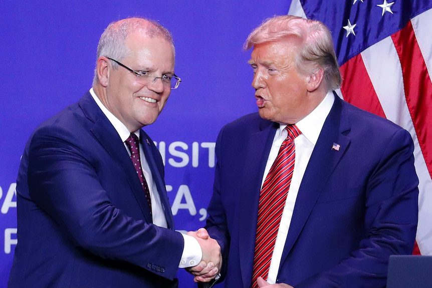
Like much of Trump’s presidency, the diagnosis was right, but the medicine was wrong.

It’s taken Joe Biden to make this deal happen, no doubt backed by US hawks.

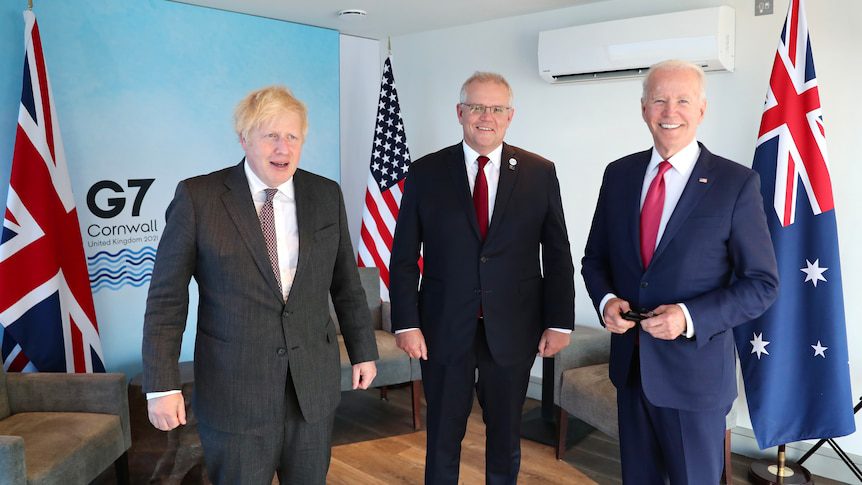
We now know what Scott Morrison, Joe Biden and Boris Johnson were discussing in their secret meetings at the G7 in June.

Since then, this deal has been negotiated very quickly.

But the devil will be in the detail, and so far, not much has been announced.

Here are the key questions:

  1. Australia doesn’t currently have a nuclear industry. Building one quickly will require the assistance of the US and UK. So what happens to the current French submarines that Australia has been spending millions on to turn from a nuclear Barracuda to a diesel Barracuda design.

2. Until now, Australians have been historically against the idea of nuclear, for safety and environmental reasons. Those concerns won’t just disappear, and the democratic process will play a key role.

3. Where will the subs be stationed when in dry dock? And what will be the community reaction? Will they be on Aboriginal land? Will they be near population centres? Will South Australia still want to be the home of our subs fleet?

4. While the US President stressed that Australia will have nuclear submarines, they won’t carry nuclear weapons. They will instead be nuclear subs with conventional weapons. This won’t be Trident.

5. It’s a long way off, but worth keeping in mind. What happens to our nuclear submarines once they reach end of life? As the British have found, they’re extremely difficult to get rid of. You don’t exactly chuck them up on eBay.

6. China has a great rate of submarine operations already., and the capacity to build more quickly. Australia is far behind, and as any military commander knows, the weapons you have at the start of a war, are the weapons you have throughout the war. Particularly if the new Aussie subs require parts from overseas, which they most certainly will.

7. Then there’s the unknown. The cost, the work and the fact that submarine construction is incredibly difficult. Think space design. The idea this will happen quickly is preposterous. It would be much easier for Australia to buy them off the shelf.

They are all questions being asked in military circles. And so far, no answers.

Ahron Young is an award winning journalist who has covered major news events around the world. Ahron is the Managing Editor and Founder of TICKER NEWS.

Click to comment

Leave a Reply

Your email address will not be published. Required fields are marked *

Ticker Views

Australia inflation, USD volatility and Fed dissent explained

Australia’s inflation report raises questions for the RBA, influencing interest rates, markets, and a volatile US dollar.

Published

on

Australia’s inflation report raises questions for the RBA, influencing interest rates, markets, and a volatile US dollar.


Australia’s latest inflation report is raising questions about the Reserve Bank of Australia (RBA) and its next moves.

David Scutt from StoneX breaks down what the numbers mean for interest rates, investors, and global markets, highlighting the ripple effects that could reach far beyond Australia.

Meanwhile, the US dollar has seen a surge in volatility, sparking concerns about the impact on Australia’s economy and global trade. David explains the challenges and potential risks of pursuing a weaker dollar policy, and what it could mean for markets in the months ahead.

Subscribe to never miss an episode of Ticker – https://www.youtube.com/@weareticke

#AustraliaInflation #RBA #USDVolatility #WeakerDollar #FedMeeting #GlobalMarkets #FinanceNews #TickerInterview


Download the Ticker app

Continue Reading

Ticker Views

The Cold War maps that can help us rethink today’s Arctic conflict

Published

on

The Cold War maps that can help us rethink today’s Arctic conflict

A US view of the cold war world, 1950, showing the fearsome power of the USSR.
Cornell University – PJ Mode Collection of Persuasive Cartography.

James Cheshire, UCL

The late 1940s and early 1950s were a golden age for polar mapmaking in the US. Major magazines such as Time, Life and Fortune commissioned a generation of famous cartographers – who had come of age in the second world war – to explain the new geopolitics to a mass audience that was highly engaged after the catastrophic global conflict they had just lived through.

Their maps were large, dramatic and designed to be spread across kitchen tables and classroom desks. And they also offered a very different perspective to the mainstream maps we have become accustomed to today.

I’ve spent the past four years unearthing maps from the late 1940s and early 1950s to research a book about a largely forgotten map library at my university, and I am always struck by how consequential they feel to the global arguments of their era. Not least because they invited debate from their readers who were asked to become global strategists by discussing the next moves in the game of geopolitics.

These maps didn’t just illustrate the world – they implored people to think about it differently. As the world enters a new period of international relations and global tensions, it’s worth considering the different perspectives maps can offer us.

With each new US foreign policy intervention – such as the US president’s current preoccupation with taking over Greenland – I have often wondered if these maps of global adversaries could have percolated into a young Trump’s mind. The world must have seemed a menacing place and it is shown on these maps as a series of threats and opportunities to be gamed, with the “Arctic arena” as a major venue.

A map showing the political alignments as they were in 1941
The World Divided is an iconic map showing the geoopolitical situation at the height of the second world war. It was created by Richard Edes Harrison and published by Fortune Magazine in August 1941.
Cornell University – PJ Mode Collection of Persuasive Cartography.

The consensus encouraged by the maps was that of alliances, most notably Nato, and US opinion tended to endorse what Henry Luce, the influential owner of Time and Life magazines, called the “American century” in which the US would abandon isolationism and take on a global role.

a map using the North Polar Azimuthal Equidisant Projection
Published in 1950, this map introduces the Azimuthal Equidistant Projection to Time Magazine’s readers.
Time Magazine

Whatever one thinks of that worldview, it was frequently framed in terms of collective responsibility rather than individual dominance. Luce argued that the “work” of shaping the future “cannot come out of the vision of any one man”.

As we can now see with Greenland, Trump has taken the geography of threats and opportunity shown on these influential maps but reached a very different conclusion: an “America first”, resulting from the vision of the US president himself.

Dawning of the ‘air age’

The skilful of the cartographers of the era played with a range of map projections that offered different perspectives of geopolitical arenas. The master of this was Richard Edes Harrison who is described by the historian Susan Schultern as “the person most responsible for sensitizing the public to geography in the 1940s. [The public] tore his maps out of magazines and snatched them off shelves and, in the process, endowed Harrison himself with the status of a minor celebrity.”

Edes Harrison adopted many projections in his work – but for maps of the Arctic, he alighted on the azimuthal equidistant projection. While this creates maps that distort the shapes of countries, it enables the correct distances to be shown from the centre point of the map.

The projection became widely used in the 1940s and 1950s (and was indeed adopted for the UN flag in 1946) because it proved effective at demonstrating the wonder of the burgeoning “air age” as commercial flights followed great circle routes over the Arctic.

World map centered on London 1945
The Air Age Map of The World, 1945 (centered on London).
The Library of Lost Maps

This contrasted with the roundabout routes that needed to be followed by ships and it also mapped the countries that bordered and occupied the Arctic with a much greater sense of proximity and threat.

Missiles and bombers were just as able to travel over the top of Earth as were holidaymakers – and this created a juxtaposition exploited by cartographers. Rand McNally, a renowned map publisher, for example, published a collection of maps entitled Air Age Map of the Global Crisis in 1949.

These set out “the growing line-up of countries and peoples behind the two rival ways of life competing for power in the 20th Century” – that is capitalism as embodied by the US and Soviet and Chinese communism.

Those who bought it were told: “Keep this map folder! It may have great historic significance a generation from now.”

Magazine insert from 1950s with a series of geopolitical maps.
This 1950s map published by Rand McNally was produced as part of a marketing campaign for Airwick air freshener, but also sought to inform the US public about the spread of communism.
Rand McNally

New world order

Donald Trump’s return to office has revived talk of a world moving beyond the assumptions of the postwar order — weakening alliances, acting unilaterally, treating territory as leverage. At the same time, maps remain one of the most trusted forms of evidence in public life.

A Mercator-shaped worldview, widely used by digital maps can distort reality – for example, making Greenland much larger than it is.

Cartographers have long known the strengths and limitations of Mercator, but Trump’s approach to foreign policy is a further reminder of the perspective we lose when we depend on the standardised views of Earth that digital maps encourage (some have also speculated that Mercator’s exaggeration of Greenland’s area heightens its real estate appeal to Trump).

Maps are powerful things and in times of crisis, or rapid change, we turn to them to help explain events and locate ourselves within them. But they can be just as much about arguments as they are facts – and Trump knows this.

The maps of the 1940s and 1950s were about a fresh (American) perspective to create a new world order. They instilled Trump’s generation with a sense of the geopolitical rivalries that tend to get washed out of generic digital maps that are most widely consumed today.

Nearly 80 years on, this order may be creaking – but the maps are still there to remind us of what’s at stake.The Conversation

James Cheshire, Professor of Geographic Information and Cartography, UCL

This article is republished from The Conversation under a Creative Commons license. Read the original article.

Continue Reading

Ticker Views

Landmark trial targets Meta, TikTok and YouTube over youth mental health

Meta, TikTok, and YouTube face trial over claims of social media addiction and mental health impact on youth.

Published

on

Meta, TikTok, and YouTube face trial over claims of social media addiction and mental health impact on youth.


Meta, TikTok, and YouTube are facing a landmark trial in Los Angeles as a 19-year-old woman alleges the platforms contributed to her social media addiction and mental health struggles.

The case is being closely watched as it could set a precedent for how tech companies are held accountable for the impact of their platforms on young users.

Dr Karen Sutherland from Uni SC joins us to break down the specific allegations, the plaintiff’s claims, and how social media use is being linked to mental health challenges. We also explore the tech companies’ legal defenses and what makes this trial such a pivotal moment in digital regulation.

The outcome of this trial could have far-reaching consequences, potentially influencing future lawsuits, federal regulations, and the national conversation around youth screen time.

Subscribe to never miss an episode of Ticker – https://www.youtube.com/@weareticker

#SocialMediaTrial #YouthMentalHealth #TikTok #Meta #YouTube #DigitalAddiction #ScreenTime #LegalBattle


Download the Ticker app

Continue Reading

Trending Now